Master plan
Stuttgart
Rosenstein
History Initial situation
The lowering of the main railway station in Stuttgart creates an 85-hectare inner-city development area. Over the next few years, the Stuttgart Rosenstein district is set to take shape in this area. In terms of location and size, the area is currently under the top ranking among the development potentials in major German cities. If designed well, it will have an impact on the city as a whole, the region and beyond – comparable to the development of Hamburg’s HafenCity or the future conversion of Tegel Airport in Berlin. However, the procedures and planning processes cannot be viewed in isolation from the planning history surrounding Stuttgart 21. The particular challenge in developing the new Stuttgart Rosenstein district is therefore not only to overcome the conflicts and reservations of the past, but also to manage the comprehensive transformation process that both climate and structural change present us with.

The competition
After urban planning competitions for the development of the district were held in 1994 and in 2005, which did not succeed in finding a way to advance the respective outcomes, a new attempt was launched in 2016. Citizens were given the opportunity to express their wishes for the new district in a large-scale informal public participation process. This resulted in the “Rosenstein Memorandum”, which defined the first fields of action to be considered in the planning process. Following another public participation process in 2018, an international open urban planning competition was formulated based on the ideas and suggestions of the citizens. The three-stage competition process then began in July 2018, from which the design by asp Architekten and Koeber Landschaftsarchitektur emerged as the winner a year later.

A mission statement for Stuttgart Rosenstein
85 hectares of vacant land in the middle of Stuttgart, which is to be developed successively over the next few decades, and a competition result that formulates a clear outcome of this development, were the starting point for the planners after the competition and the commissioning of the development of a master plan. The challenge was not only the scale of the project but, above all, reconciling the contradictions of a dense, yet climate-adapted city under the explicitly formulated guiding principle of “urban. resilient. radically green.” But also, to develop the masterplan as a blueprint for the future.
This prompted the idea of developing a master plan that breaks free from conventional approaches. It differs from a classic master plan in that it not only shows the development of an urban area. Its main task is to provide a guide for the development of a completely new part of the city. This means: On the one hand, it must provide a clear direction by defining the urban development qualities. On the other hand, it must address future issues, some of which can only be answered in the course of the process. Consequently, it must endeavour to explore ways of breaking new ground. The masterplan plan must therefore be sound, and yet adaptable.

The structure of the masterplan
The idea of compiling a multi-part document was born to fulfil these dual requirements. The masterplan forms a robust and resilient framework for the visions of the city, which can be modified and supplemented over the years. These visions are presented in four in-depth documents, known as briefings, which are then harmonised with each other. The four documents are separate, as they address specific solutions for each of the four sub-areas – Rosensteinquartier, Europaquartier, Maker City and Gleisbogenpark. Yet the masterplan ties them together and allows them to adapt to changing conditions without losing reference to each other.
Methodology and application
As the requirements arising from the history of the location and the needs of climate and structural change are diverse and often seem contradictory, it became apparent that they cannot be resolved within a traditional urban masterplan. The planners worked across different scales to understand problems in detail and derive specific solutions. However, these are not understood as final design proposals to be built in a few years’ time but rather as possible approaches to dealing with these challenges.
This cross-scale approach allowed the brief to be viewed from different disciplines and perspectives, from the macro to the micro scale and back. Planning levels were connected both locally and at a higher level. Hence, problems that could not be solved at the scale of the masterplan and its layers were assessed in detail and clarified in briefings. The content of the briefings provides the basis to adapt them to the requirements at hand in the ongoing process. The layer plans, as part of the urban masterplan, balance different requirements, such as species protection and cold air flows versus building heights and urban density.


Urban development concept
A robust framework
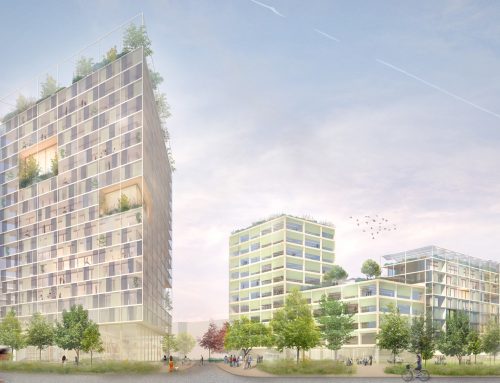
The planners have divided the Stuttgart Rosenstein development area into a total of four sub-areas: While the Europa Quarter and the Rosenstein Quarter are mainly dedicated to living and working, the so-called Maker City, following the principle of the Productive City, serves as an urban laboratory. These three sub-areas are connected by the Gleisbogen Park, which resembles a green axis. The design proposes to keep the “extended” curve of the Gäubahn railway track free from buildings and shape it into the backbone of the new expanded city centre. As an urban junction, it connects the northern and eastern districts while also serving as a city-wide development axis along which the city can gradually expand towards the Neckar River. The new “Parkbogen” incorporates all the functions of a modern green infrastructure and, originating from the railway station, connects existing and new neighbourhoods to form a coherent entity.
In its character as a densely programmed open space, it takes on important recreational, cultural, sporting, and social activities as an urban complement to the landscaped recreational space of Rosensteinpark and continues the urban foot and cycle path network towards the Neckar and the Feuerbach district. It is also home to areas for urban agriculture. In addition to its role as a “Social Space,” the Gleisbogen Park is of paramount importance in terms of species protection, habitat connectivity, and urban climatic conditions. Parts of the existing topography will be preserved and integrated into a dense network of green spaces. This develops, for example, along access structures, in unsealed squares and courtyards, etc. Measures to protect species (animal-aided design) on facades and roof surfaces extend the network down to building level. All these measures ensure the continued preservation of existing and new habitats while reducing the development of heat islands.

Integration into the surrounding fabric
Linking the new urban neighbourhoods to their surroundings is a key aspect of the concept. The aim is to create diverse neighbourhoods that are well-integrated living spaces rather than isolated areas. Existing connections, structures, and sightlines of the adjacent city (Nordbahnhof district and Stuttgart East) are incorporated and extended into the new district. The existing block structures of the listed railway worker’s district serve as the basis for a connecting “bracket” of the new district. This creates plots of land whose shape and size are adequate for the formation of manageable neighbourhoods with distinct identities. This creates sightlines to the major “Stuttgart landmarks” such as Rotenberg, TV tower, Rosenstein Castle, and views into the landscape of Rosenstein Park.
The planners decided to emphasise the curved shape of the former railway line on the edge of the new park, to set high points as urban design features and to define clear spatial edges. The interaction of open spaces, path connections and urban spatial references on the one hand and qualities of places, uses and typologies on the other will create a coherent district from the Nordbahnhofviertel and the new neighbourhoods with the Gleisbogenpark as a common centre and a series of connected open spaces at the neighbourhood level.


Neighbourhoods as centres of life
Virtually car-free, dense and at the same time green neighbourhoods were chosen as the guiding principle for the new urban districts. The individual neighbourhoods are given local squares, each assigned with a hybrid neighbourhood hub. In the hubs, local supply, social infrastructure, new mobility, energy and material flows are bundled in a sustainable way. Square and hub form the heart of every neighbourhood. At its core, the hub is designed as a neighbourhood car park and can be adapted and repurposed to meet changing mobility needs. The buildings are categorised according to their location with regard to ground floor occupancy and floor plan typologies. Towards Gleisbogenpark and the access roads, the ground floor will accommodate predominantly public amenities such as shops, cafés, local supply, and services, while social and communal facilities such as daycare centres, small businesses, co-working spaces etc. will be organised around the local square. Residential flats are located above. The inner access routes are designed as green residential paths, with stacked townhouses or maisonettes already on the ground floor.


Process-oriented dialog
A new form of communication
A project of this size, with such political and social relevance, requires a different, new form of communication – on many levels: between those involved in planning, with the stakeholders and the specialist disciplines, but equally between the planning contents themselves, which must enter into a kind of dialogue with each other. In addition to the planning requirements and the skilled work of planning and construction, it was therefore necessary to interlink the various phases of project development with an integrated communication and participation concept in a manner that allows opportunities and potentials to be recognised and a favourable engagement of urban society (citizens, associations, administration, politics, etc.) with the project to be promoted and facilitated.
The aim was to understand urban development not only theoretically but as a discursive process, actively connecting top-down and bottom-up approaches. It was clear at this point that we needed to depart from a linear planning process and break the planning into iterative cycles, ultimately allowing adjustments to be made so that the process – especially given its long-term perspective – could be adapted to changing needs and requirements at a later stage.

This gave rise not only to the format of the Interdisciplinary Planning Groups (IPGs), to which not only the specialist planners but also the responsible authorities were invited to negotiate perceived contradictions at planning level. But the workshop format also provided a neutral setting for discussions with politicians. With the “Stuttgart Rosenstein C1 stakeholder process”, in turn, a participation format was created that was initially carried out as an example for the Maker City sub-area because this will be the first to be realised. But it should basically be seen as a model for the development of the other sub-areas. Finally, during the development phase of the masterplan, citizens had the opportunity to contribute their suggestions and ideas on various topics through various online and offline formats over several months, which were ultimately considered in the final version of the masterplan.
The Stuttgart Rosenstein master plan was awarded the Special Prize 2023 in the “Shaping climate adaptation” category by the Deutschen Städtebaupreis.

Project information
Name: Master plan Stuttgart Rosenstein
Project type: Development of an urban master plan
Location: Stuttgart
Completion: 2023
Client: Landeshauptstadt Stuttgart
Planning partners: Koeber Landschaftsarchitektur GmbH, Köhler & Leutwein (engineering office for transportation), Claudia Georgius (stakeholder process)
Project team: Alexa Appenzeller, Raphael Dietz, Nadine Funck, Ellen Henriques, Deborah Kunz (project management), Philipp Maué, Nicole Ottmann, Clara Scherer, Theresa Zorn
Images and visualizations: asp Architekten
Award: Deutscher Städtebaupreis 2023 special category “Shaping climate adaptation”